Follow along with the video below to see how to install our site as a web app on your home screen.
Note: This feature may not be available in some browsers.
From a "listserve"(NextDoor) associated with Buncombe County.
"My husband and I spent the months since Helene cleaning up and repairing damage caused to our property by high winds. More than 30 trees were toppled. We are both 73 and have no family nearby, making the process difficult and at times overwhelming. While dealing with this, we decided we had reached a time in our lives when we should move out of our house into independent living. We did this, but now we find ourselves living in another nightmare. We can’t sell our house. A prospective buyer, who loved our house but decided not to buy it, informed us that our house supposedly has a 99.9% chance of flooding in the next 30 years. This led to the discovery that most if not all major real estate websites now display climate risk factors generated by First Street, a climate risk financial modeling firm based in New York. First Street assigned our property at 17 Bohemian Lane, Asheville, NC, a 10/10 Extreme flood risk factor, their highest rating. This is absurd:
1. It is physically impossible for our property to flood. It’s located above 2500 feet on sloping terrain. Water cannot collect on it. During Helene and the three days preceding the storm, an estimated 18 to 22 inches of rain fell where we live. There was no flooding on our property—none. Rainwater drained down the mountainsides and flooded valleys. Mountain tops and mountain sides did not flood, not even during Helene.
2. The flood risk designations First Street’s has assigned to our property and to our next-door neighbors’ (downhill from us) defy the laws of physics and logic. First Street says our property has a 10/10 Extreme flood risk, while the adjacent property and the one next to it have a 1/10 Minimal flood risk. It’s not possible for adjacent properties to have polar opposite flood risks. Water doesn’t stay within property lines. Moreover, our house is at the highest elevation among the three, and water flows downhill.
3. Both FEMA and the North Carolina Emergency Management Flood Risk Information System (NCEM FRIS) place our property in Zone X (unshaded), their lowest ratings. First Street’s methodology is clearly flawed. Yet, they refuse to make corrections. The dispute policy on their website states this: “If you contact customer support regarding a score dispute, you should not expect a personalized response."Real estate websites likewise have refused to remove First Street’s erroneous flood risk information, with one exception.
Realtor.com removed the flood risk information for our property.We filed a complaint with the BBB and have written dozens of emails to real estate websites, realtor associations, state and federal senators and representatives, our governor, the NC DOJ, the FTC, FEMA, and new media. Most haven’t responded. The rest can't or won't help.
Worse yet, we are far from alone, as evidences by unresolved complaints to the Better Business Bureau and online discussions in which other people share stories similar to ours. First Street Technology, Inc. | BBB Complaints | Better Business BureauFirststreet is rated "Poor" with 2.3 / 5 on Trustpilot
If you want to see how First Street rates your property, go to their website: firststreet.org. Put in your address at the top of the page. First Street, claiming to be highly scientific and accurate, is aggressively marketing its faulty flood risk data to real estate, insurance, and mortgage companies; and to the public--and many are literally and figuratively buying it. You can see it on their website (The Standard for Climate Risk Financial Modeling) as well as in articles like this: https://www.cnn.com/2025/05/19/climate/flooding-credit-homeowners-insurance. First Street is destroying property values and squelching home sales nationwide with faulty data. One of the blessings of Helene was experiencing how people came together to help one another through the worst of it. I hope and pray that good people working together can raise awareness and work together to stop this company's destruction and repair the damage already done."
I wonder if there was somewhere else that 40 could have went through in the mountains that would have been better.
I think following the Pigeon river for that stretch is really the only route that makes sense when you look at a map. It’s just a really “dense” area of the mountains. The alternatives would have changed the direction and areas served by the interstate pretty significantly.I wonder if there was somewhere else that 40 could have went through in the mountains that would have been better.
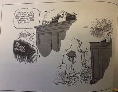
Somewhat off topic and non-responsive to your post, but your comment reminded me of a cartoon drawn by Dwane Powell in the 1970's when he was a political cartoonist for the Raleigh N&O.I think following the Pigeon river for that stretch is really the only route that makes sense when you look at a map. It’s just a really “dense” area of the mountains. The alternatives would have changed the direction and areas served by the interstate pretty significantly.
Pfft. It sounds like you know what you're talking about. Didn't you get the memo? The US is so done with science and conservation. Go crawl in a hole and await the Second Coming . . .One thing my natural resources colleagues in NC are worried about is the damage the river cleanup crews are doing to the rivers they are supposed to be cleaning. Army Corps contracts companies and pays by the load-which incentivizes these companies to rip anything they can out of the streambed or banks. That includes whole rooted trees and downed trees in the water that have provided habitat for many years. The result may be stream beds filling in due to erosion and even worse flooding the next time a disaster hits.
One thing my natural resources colleagues in NC are worried about is the damage the river cleanup crews are doing to the rivers they are supposed to be cleaning. Army Corps contracts companies and pays by the load-which incentivizes these companies to rip anything they can out of the streambed or banks. That includes whole rooted trees and downed trees in the water that have provided habitat for many years. The result may be stream beds filling in due to erosion and even worse flooding the next time a disaster hits.
The fish hatcheries in the mountains will be absolutely vital for the next 2-3 years. I'm confident in NC and SC, believe it or not. If TN and GA stay strong, the mountain fish populations should rebound quickly.As an avid fisherman I've worried about the impact the storm had and will continue to have on the region.
I frequently drove 40 from Tennessee to Chapel Hill in the early 90s -- back before you could use your phone to find the nearest gas. The first time I did that trip I almost ran out of gas because of the lack of stations between Knoxville and Ashville, especially right around the NC/TN state line. Not a lot of civilization in that stretch.I think following the Pigeon river for that stretch is really the only route that makes sense when you look at a map. It’s just a really “dense” area of the mountains. The alternatives would have changed the direction and areas served by the interstate pretty significantly.
Me too. I planned ahead, though. Gassed up West of Knoxville headed East and Ashville headed West. Knoxville had a 55 mph speed zone for like 30 miles as if it was some sort of bustling metropolis of great importance. Most people just want to get through.I frequently drove 40 from Tennessee to Chapel Hill in the early 90s -- back before you could use your phone to find the nearest gas. The first time I did that trip I almost ran out of gas because of the lack of stations between Knoxville and Ashville, especially right around the NC/TN state line. Not a lot of civilization in that stretch.