Navigation
Install the app
How to install the app on iOS
Follow along with the video below to see how to install our site as a web app on your home screen.
Note: This feature may not be available in some browsers.
More options
You are using an out of date browser. It may not display this or other websites correctly.
You should upgrade or use an alternative browser.
You should upgrade or use an alternative browser.
3/14-3/16 Severe Weather Threat
- Thread starter TurdFerguson
- Start date
- Replies: 46
- Views: 1K
- Off-Topic
Duke Mu
Iconic Member
- Messages
- 2,462
We're lucky the NWS and NOAA are not shuttered yet. All Sharpie, all the time.
Duke Mu
Iconic Member
- Messages
- 2,462
Yeah, because of Climate Change, the South is the new Tornado Alley. High shear and instability, sucking up that Gulf moisture.
- Messages
- 8,536
Yep. The local meteorologists down here basically said this morning, "usually when we tell you about the probability of tornadoes, it's just that- a chance. Today, it is a certainty."A TorCon of 9???????
I've never seen that before. I get before with a 2 or 3
That means there's a 90% chance of a tornado within 50 miles of your location. Holy shit
1moretimeagain
Inconceivable Member
- Messages
- 4,841
I used to love meteorologist Eric Thomas’ tornado warning recommendation that if you’re outside you should lie down in a ditch. You know a day has not gone your way when your best option is laying in a ditch during a storm.
Thanks for the update. My grandson is in Tuscaloosa too. He’s thinking about going to Alabama and is down there with his sister.Yep. The local meteorologists down here basically said this morning, "usually when we tell you about the probability of tornadoes, it's just that- a chance. Today, it is a certainty."
JCTarheel82
Inconceivable Member
- Messages
- 2,872
Sheesh. You know it's serious when Waffle House closes up shop.Both of the Chick-fil-A’s near my house in Birmingham are already closed today citing the threat of tornadoes, and the Waffle House across the street from one of them has a “closing early” sign. Yikes.
TurdFerguson
Legend of ZZL
- Messages
- 6,993
MS is getting hit hard by tornadoes right now.
TurdFerguson
Legend of ZZL
- Messages
- 6,993
TurdFerguson
Legend of ZZL
- Messages
- 6,993
445 PM CDT SAT MAR 15 2025
THE NATIONAL WEATHER SERVICE IN BIRMINGHAM HAS ISSUED A
* TORNADO WARNING FOR...
NORTHWESTERN TUSCALOOSA COUNTY IN WEST CENTRAL ALABAMA...
EASTERN FAYETTE COUNTY IN WEST CENTRAL ALABAMA...
* UNTIL 545 PM CDT.
* AT 445 PM CDT, A CONFIRMED LARGE AND EXTREMELY DANGEROUS TORNADO
WAS LOCATED NEAR GORDO, MOVING NORTHEAST AT 55 MPH.
THIS IS A PARTICULARLY DANGEROUS SITUATION. TAKE COVER NOW!
HAZARD...DAMAGING TORNADO.
SOURCE...RADAR CONFIRMED TORNADO.
IMPACT...YOU ARE IN A LIFE-THREATENING SITUATION. FLYING DEBRIS
MAY BE DEADLY TO THOSE CAUGHT WITHOUT SHELTER. MOBILE
HOMES WILL BE DESTROYED. CONSIDERABLE DAMAGE TO HOMES,
BUSINESSES, AND VEHICLES IS LIKELY AND COMPLETE
DESTRUCTION IS POSSIBLE.
* LOCATIONS IMPACTED INCLUDE...
STONE WALL, WHITSON, BOLEY SPRINGS, BANKSTON, MOORES BRIDGE, BERRY,
WINDHAM SPRINGS, SAMANTHA, FAYETTE COUNTY PUBLIC LAKE, NEW
LEXINGTON, WILEY, ECHOLA, AND BINION CREEK LANDING.
TurdFerguson
Legend of ZZL
- Messages
- 6,993
Hope it won't be too bad in NC tomorrow.
circlesky88
Esteemed Member
- Messages
- 619
First chance for Trump's FEMA to show it's mettle.
First chance for Trump's FEMA to show it's mettle.
They already had that chance with the Valentine’s Day flooding in Kentucky and West Virginia and totally blew it. And there’s been very little media coverage of how terrible the response has been.
TurdFerguson
Legend of ZZL
- Messages
- 6,993
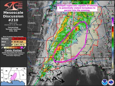
Alabama getting hit with multiple tornadoes now.
TurdFerguson
Legend of ZZL
- Messages
- 6,993
Tornado on the ground near Taladega.
My grandchildren in Tuscaloosa said they got a lot of rain and wind, but no tornadoes. There was one touch down about 20 miles north of town.Alabama getting hit with multiple tornadoes now.
Can’t sleep either. That weather heading our way here in central NC. Was going to cut grass today. Oh well.Can't sleep.
The rain here in Georgia is pretty intense and a lot of wind. I believe the worst is missing us though.
Share:


