Navigation
Install the app
How to install the app on iOS
Follow along with the video below to see how to install our site as a web app on your home screen.
Note: This feature may not be available in some browsers.
More options
You are using an out of date browser. It may not display this or other websites correctly.
You should upgrade or use an alternative browser.
You should upgrade or use an alternative browser.
The Weather Thread
- Thread starter nycfan
- Start date
- Replies: 2K
- Views: 72K
- Off-Topic
- Messages
- 991
That was also the forecast early this morning. Scheduled all of my errands around the forecast to avoid it. Ended up sitting outside in the nice weather this afternoon that was supposed to be all rainThat’s insane. Yesterday’s forecast for Charlotte was that it would rain all day today and we would get some heavy rain. We didn’t get a drop today, and it was actually pretty nice out. And the temperature didn’t get above 80, which never happens here in July.
- Messages
- 1,560
This storm seemed an anomaly as usually the Eno or Haw are attractive to these but apparently this was stuck in the middle for about two hours and a shit ton of rain?
ETA: God help the folks in Texas too.
ETA: God help the folks in Texas too.
1moretimeagain
Inconceivable Member
- Messages
- 3,968
1moretimeagain
Inconceivable Member
- Messages
- 3,968
Last edited:
1moretimeagain
Inconceivable Member
- Messages
- 3,968
Last edited:
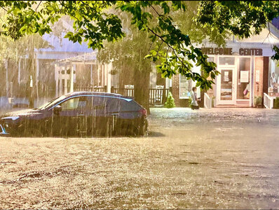
That part of Chapel Hill has flooded in heavy rains for decades.Evacuations are underway at Camelot Village in Chapel Hill.
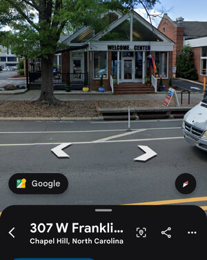
It’s part of the flood plain at the bottom of Stroud/Strowd Hill (Franklin Street at Estes).
The creek is Bolin Creek (Airport Road/MLK Boulevard drain into it; parts of Carrboro drain into it). If you’ve ever seen Umstead Drive and/or Park flood, that’s Bolin Creek.
Bolin Creek and Booker Creek (it is supposed to flow UNDER Eastgate Shopping Center) meet at about Estes and the By-Pass - call it the Rainbow Soccer Fields.
Just east of Chapel Hill, Morgan Creek (the creek that floods the soccer practice fields, the T&F facility, and Finley Golf Course), Bolin Creek, Booker Creek, and New Hope Creek all meet in that flooded swampy area where 15-501 Boulevard, Hwy 54, 751, and I-40 either intersect or get damn close to one another.
Nothing would be built at Camelot Village today.
That’s Mallette and Franklin at where the old Fowler’s was (think Big Bertha and beer). Franklin Street goes downhill from both east and west to Mallette……Cameron Avenue is above/higher in elevation than Franklin…..decades and decades ago, a creek flowed north from their through the Northside neighborhood.
That section often floods. Floods have gone into the parking garage of the hotel next to the Dead Mule.
In the late ‘80’s we’d surf whitewater kayaks on West Franklin.
We humans build stuff where we shouldn’t and expect nature to accommodate us.
Doesn’t bode well for my old haunts at Squid’s. Hope it doesn’t get hit too bad.
Eastgate has flooded since it was built in 1958.Doesn’t bode well for my old haunts at Squid’s. Hope it doesn’t get hit too bad.
Nothing should have been built there.
It’s a fucking flood zone “uphill” from a swamp close to the confluence of New Hope, Booker, Bolin, and Morgan Creeks.
Booker Creek ostensibly runs under Eastgate headed towards the Rainbow Soccer fields, University Mall, Glen Lennox…..you know……places that flood in heavy rains.
Squids has generally been just high enough to not swamp.
1moretimeagain
Inconceivable Member
- Messages
- 3,968
I have a sister in Hillsborough, she said it was the heaviest rain she’s ever experienced.
Yes. Eastgate floods all the time. But this one looks like it has swamped the Elliot road area too, so that doesn’t bode well.Eastgate has flooded since it was built in 1958.
Nothing should have been built there.
It’s a fucking flood zone “uphill” from a swamp close to the confluence of New Hope, Booker, Bolin, and Morgan Creeks.
Booker Creek ostensibly runs under Eastgate headed towards the Rainbow Soccer fields, University Mall, Glen Lennox…..you know……places that flood in heavy rains.
Squids has generally been just high enough to not swamp.
The Eastern Portion of Elliot Road is basically Eastgate and the SWAMP to the east of Chapel Hill…….with more roofs and pavement than 5 years ago…..especially on the Colony Woods/Ridgefield/Ephesus Church side of “The By-Pass.”Yes. Eastgate floods all the time. But this one looks like it has swamped the Elliot road area too, so that doesn’t bode well.
It’s laughable the development that Chapel Hill has permitted in that SWAMP (15-501 Boulevard/Eastgate/East Elliot Road [yes, it exists]/Estes/University Mall/Rainbow Fields/Glen Lennox).
The area floods if 20 guys go outside to pee.
Duke Mu
Iconic Member
- Messages
- 1,947
These Warm Core beasts.
donbosco
Legend of ZZL
- Messages
- 6,638
Friend in North Chatham writes:
“Earlier tonight on Bynum Bridge... the water levels went from four feet to 18 feet in 3 hours! 60,000 cubic feet of water ( and giant logs) were passing under the bridge per second!
The bridge also flooded a fifth of the way across not from the river itself, rather from the water and debris pouring down the hill and blocking the drain holes turning the bridge into a chute.”
- Messages
- 1,147
poor girls at the christian camp
lawtig02
Legend of ZZL
- Messages
- 5,789
Every time I catch up on the news from Texas, I’m more shocked. Yes, this is a notoriously flood prone area. Yes, it was a holiday weekend with a lot of campers. Yes, the children’s camps massively increased the risk. But how did this storm (likely) kill more people than died in all of WNC during Helene? To be fair, I was surprised (and very thankful) more people did not die in Helene, but the scale of this Texas tragedy is just astounding.
- Messages
- 2,926
With Helene, there had been warnings for a few days that a tropical storm would make its way through that part of the state. Because of the warnings and because it was a tropical storm (vs. forecasts of just rainfall), most of those who remained in the area sheltered in secured structures, and you didn’t have people out camping by the rivers or just being out and about.Every time I catch up on the news from Texas, I’m more shocked. Yes, this is a notoriously flood prone area. Yes, it was a holiday weekend with a lot of campers. Yes, the children’s camps massively increased the risk. But how did this storm (likely) kill more people than died in all of WNC during Helene? To be fair, I was surprised (and very thankful) more people did not die in Helene, but the scale of this Texas tragedy is just astounding.
With the Texas flooding, while it is related to a tropical storm, the tropical storm itself was not making its way to that area. There weren’t the same level of warnings. And people were out camping, being out and about, and not sheltering in secured structures.
Share:


