Navigation
Install the app
How to install the app on iOS
Follow along with the video below to see how to install our site as a web app on your home screen.
Note: This feature may not be available in some browsers.
More options
You are using an out of date browser. It may not display this or other websites correctly.
You should upgrade or use an alternative browser.
You should upgrade or use an alternative browser.
Helene Recovery & Info
- Thread starter TullyHeel
- Start date
- Replies: 1K
- Views: 48K
- Off-Topic
sunnyheel
Well-Known Member
- Messages
- 92
Checking in from high ground (ha!) inland of Tampa. Our home in St. Petersburg was under mandatory evacuation since Wednesday (just lifted) so we fled and will remain away until the sewer system in St. Pete is functional. It could be a few days.
Here’s the interesting part. St. Pete is old by Florida standards and it has a traditional city sewer system that was constructed starting in the 1920s. It’s basically the same infrastructure today but managing the volume of a real city with high rises etc.
We have been experiencing record-breaking flooding all summer due to heavy (but not aberrational) rains. Meaning that even non-tropical storms can easily overwhelm the system now due to the combination of insufficient capacity and sea level rise.
There is no easy solution and it will become worse with each passing year. I’m expecting a reversal of the influx of residents and lower property values.
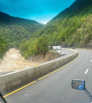
If it was a slide, you’d have trees, rocks, and mud all over the road.Since we have someone here who knows about floods from an engineering perspective, are those lanes "washed away" in the sense that the water caused the bridge to collapse, or was there a rock slide that took out the road?
- Messages
- 3,951
They are worried about unions "for national security purposes," but want to privatize TSA screening? Really? No holes in that plan.eliminating most of DHS’s grant pro- grams, and removing all unions in the department for national security purposes."
uncgriff
Honored Member
- Messages
- 887
Insurance is going to be the rate limiting step. Florida is basically a bomb waiting to go off every year at this point on the insurance companies finances.Checking in from high ground (ha!) inland of Tampa. Our home in St. Petersburg was under mandatory evacuation since Wednesday (just lifted) so we fled and will remain away until the sewer system in St. Pete is functional. It could be a few days.
Here’s the interesting part. St. Pete is old by Florida standards and it has a traditional city sewer system that was constructed starting in the 1920s. It’s basically the same infrastructure today but managing the volume of a real city with high rises etc.
We have been experiencing record-breaking flooding all summer due to heavy (but not aberrational) rains. Meaning that even non-tropical storms can easily overwhelm the system now due to the combination of insufficient capacity and sea level rise.
There is no easy solution and it will become worse with each passing year. I’m expecting a reversal of the influx of residents and lower property values.
aGDevil2k
Inconceivable Member
- Messages
- 4,627
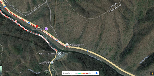
Looks like the Pigeon River completely undercut the road and it collapsed into the river. You can see the bank erosion and the river roaring. That would be erosion versus a rock slide...so how they repair it? No clue. I would guess it's going to demand a bridge because the river is going to do what rivers do....and bank stabilization is not a short process.Since we have someone here who knows about floods from an engineering perspective, are those lanes "washed away" in the sense that the water caused the bridge to collapse, or was there a rock slide that took out the road?
uncgriff
Honored Member
- Messages
- 887
Yeah. And the river is continuing to undercut every minute.Looks like the Pigeon River completely undercut the road and it collapsed into the river. You can see the bank erosion and the river roaring. That would be erosion versus a rock slide...so how they repair it? No clue. I would guess it's going to demand a bridge because the river is going to do what rivers do....and bank stabilization is not a short process.
aGDevil2k
Inconceivable Member
- Messages
- 4,627
Yeah I dont know the volume of Lake Lure...but a breach on top of already significant elevated flood stages (I mean little Cove Creek downstream of Lake Lure is already 7 feet over flood stage), and it's just...whew. The other thing a breach at flood stage creates is less friction and resistance from the ground, so the wall of water would go further than it happening in dry weather. So whether it stops the massive flooding by Rutherfordton or goes all the way to I-85, I have no idea. But I do know they told people even down near Cliffside to be on guard, and that's at the Cleveland/Rutherford border.OK, I'll go with "informed opinion." I also understand that it's a rough estimate. If the flooding goes only 35 miles, you won't have been wrong. Just imprecise.
Anyway, thanks. Now I know. I suspect I was overestimating the amount of land the water can spread over. My main experience with floods was the major flood of 93 in the Midwest, as I was doing some work in Illinois and Missouri. So I'm envisioning a field covered with water in every direction, which is probably not what a flood looks like in the foothills. The water is more channeled and thus more concentrated.
- Messages
- 1,569
So if an oxbow in the river they'll have to move the road over I'm thinking.
- Messages
- 773
The most important thing are the lives homes and any buildings below Lake Lure. As I recall there's not much around Lake Lure, it is a decent distance from Asheville and other towns.
But I sure hope the dam and Lake hold. That is a beautiful clean Lake nestled in a beautiful area of the mountains. I believe there are a couple of resort cabins and houses around it.
superrific
Master of the ZZLverse
- Messages
- 12,127
Is your background civil engineering?Looks like the Pigeon River completely undercut the road and it collapsed into the river. You can see the bank erosion and the river roaring. That would be erosion versus a rock slide...so how they repair it? No clue. I would guess it's going to demand a bridge because the river is going to do what rivers do....and bank stabilization is not a short process.
superrific
Master of the ZZLverse
- Messages
- 12,127
You might have determined already that I'm not familiar with the area. LOL.If it was a slide, you’d have trees, rocks, and mud all over the road.
It's funny -- I love mountains, but I've never lived close to a mountainous area and I only vacation there sporadically. Part of it is that I really like the high mountains. The small mountains in the US East aren't that exciting. Some of them up north are barely more than hills. Anyway, I don't know shit about mountain storms. OTOH if you need to know how to get from Coney Island to Brooklyn Heights in two feet of snow, I can help you with that (or at least could a few years ago).
- Messages
- 1,569
aGDevil2k
Inconceivable Member
- Messages
- 4,627
Yup - Water resources to be exact. 2 degrees in it...until I moved over to tech marketing 15 years agoIs your background civil engineering?
aGDevil2k
Inconceivable Member
- Messages
- 4,627
Unreal. That part of 40 was a huge mess when they were doing construction on it the last time I drove that way (2021). Will be a months long headache for people that use that route regularly.
JCTarheel82
Iconic Member
- Messages
- 2,458
I drove through that area in April of this year and it was still a mess.Unreal. That part of 40 was a huge mess when they were doing construction on it the last time I drove that way (2021). Will be a months long headache for people that use that route regularly.
TarHeelGrad
Exceptional Member
- Messages
- 202
You know how they say that six inches of water can sweep you off your feet? Look what it can do to cars.
TarHeelGrad
Exceptional Member
- Messages
- 202
I'm in the Sarasota area. Love St Pete. But both St Pete and Tampa have some really old areas that are not made to withstand these types of storms.Checking in from high ground (ha!) inland of Tampa. Our home in St. Petersburg was under mandatory evacuation since Wednesday (just lifted) so we fled and will remain away until the sewer system in St. Pete is functional. It could be a few days.
Here’s the interesting part. St. Pete is old by Florida standards and it has a traditional city sewer system that was constructed starting in the 1920s. It’s basically the same infrastructure today but managing the volume of a real city with high rises etc.
We have been experiencing record-breaking flooding all summer due to heavy (but not aberrational) rains. Meaning that even non-tropical storms can easily overwhelm the system now due to the combination of insufficient capacity and sea level rise.
There is no easy solution and it will become worse with each passing year. I’m expecting a reversal of the influx of residents and lower property values.
- Messages
- 3,951
Truckers are cursing at the prospects of years of workarounds.Unreal. That part of 40 was a huge mess when they were doing construction on it the last time I drove that way (2021). Will be a months long headache for people that use that route regularly.
Share:


