The Weather Thread

  • Thread starter Thread starter nycfan
  • Start date Start date
  • Replies: 331
  • Views: 6K
  • Off-Topic 
Hitting 20-30 miles south of Tampa Bay likely dramatically changes (reduces) the storm surge in the Tampa Bay area…….this storm is going to be devastating, regardless.
That would be in the eyewall. However, the storm surge would be partially abated by east winds. More wind damage and less surge damage.
 
My boss lives south of Tampa between TB and Sarasota but a decent bit in from the shore. I messaged her on Sunday about having a plan for this storm and her plan was to stay put. I asked again today and now she's pretty nervous, but she is outside the evacuation and flood zones. I think the bigger concern for her spot is wind and tornados but she seems to be directly in the path of the storm as it shifts south.

Pretty much her whole neighborhood stayed. I think people in Florida and everywhere are becoming somewhat desensitized to Cat 3 and below storms and it emboldens people to stay in their homes when perhaps they should evacuate. Given how many major storms have come ashore in the past 3 years, I cannot understand why people would stay, but when I first asked about her plans, Milton wasn't near the storm it is now nor was it really projected to be this Cat5 monster.

One of the things that I think is going to be particularly destructive about Milton is much of the near shore area had flooding from Helene and they have stacks of debris outside their homes. The storm surge is going to take that debris and batter houses. I think we will see far more houses battered down to the frame or foundation that otherwise might have survived albeit with significant flood damage. Milton is going to be unique.
 
5Am update: Hurricane Milton remains a category 5 hurricane with maximum sustained winds of 160mph.. central pressure 907mb.. movement is northeast at 14mph.
 
Clearwater waterfront camera, though it will be too dark to see anything when it lands tonight.

 
8 am update: 155 mph - cat 4, but right on the line

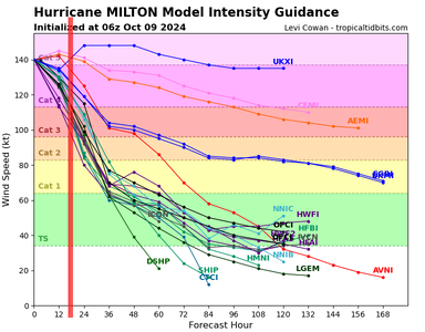
Intensity models: Red line added by me for landfall window.

14L_intensity_latest (1).png
 
I think all that can be hoped for is it stays south of Tampa Bay to lessen storm surge. Sucks for the towns to the south of it, but there are some barrier islands down that way. Humans are stupid though and have built on them.

My grandparents lived in Venice for 20 years and my grandfather was terrified of a hurricane hit. Good chance Venice could take the eye wall. He died a year ago so he won't have to witness it.
 
We were on the MS Gulf Coast when Zeta hit in 2020. I was active military at the time so didn’t have the option to leave, but the wife & kids decided to ride it out since it would “only” be a Cat 1. It made landfall in Louisiana as a 3, and was still a fairly strong 2 when it passed through our area.

Fortunately our house didn’t take any damage since we had just put a new roof on, but most of our neighbors had to either replace or repair their roofs. We were also out of power for several days. We no longer live in a hurricane zone, but no way I’d ride out anything stronger than a 2 again.
 
Back
Top