Navigation
Install the app
How to install the app on iOS
Follow along with the video below to see how to install our site as a web app on your home screen.
Note: This feature may not be available in some browsers.
More options
You are using an out of date browser. It may not display this or other websites correctly.
You should upgrade or use an alternative browser.
You should upgrade or use an alternative browser.
Helene Recovery & Info
- Thread starter TullyHeel
- Start date
- Replies: 1K
- Views: 48K
- Off-Topic
gtyellowjacket
Inconceivable Member
- Messages
- 2,993
Looks like Rutherfordton and maybe Forest City are about 15 miles away. Gaffney of the giant peach/butt water tower fame is about 50 mi away.Any idea what's at least 50 mi downstream? Any towns? Lots of houses?
superrific
Master of the ZZLverse
- Messages
- 12,127
Is this an informed estimate or just pulled out of your you-know? Because 50 miles is a long distance. I have trouble believing the damage would be catastrophic that far downstream, but I'm just pulling that out of my you-know.no could be about it. at least 50 miles downstream, I would imagine, would be obliterated
My mothers house had never flooded in the 30 years she lived there, a few close calls with a rapidly rising creek in her back yard but never enough to enter the house. In August the tropical storm that came through changed that, she was on vacation and her entire basement flooded. Just got new carpet put in this week and BAM, Helene. Thankfully I made it over last night with a water barrier I purchased off of Amazon which spared her from disaster #2. Tell me again about climate change being a hoax....
C-Money
Legend of ZZL
- Messages
- 5,614
Tornado Warning
NCC069-077-181-185-271715-
/O.NEW.KRAH.TO.W.0050.240927T1643Z-240927T1715Z/
BULLETIN - EAS ACTIVATION REQUESTED
Tornado Warning
National Weather Service Raleigh NC
1243 PM EDT Fri Sep 27 2024
The National Weather Service in Raleigh has issued a
* Tornado Warning for...
Vance County in central North Carolina...
West central Warren County in central North Carolina...
Eastern Granville County in central North Carolina...
Northwestern Franklin County in central North Carolina...
* Until 115 PM EDT.
* At 1242 PM EDT, a severe thunderstorm capable of producing a
tornado was located near Franklinton, or 10 miles west of
Louisburg, moving north at 40 mph.
HAZARD...Tornado.
SOURCE...Radar indicated rotation.
IMPACT...Flying debris will be dangerous to those caught without
shelter. Mobile homes will be damaged or destroyed.
Damage to roofs, windows, and vehicles will occur. Tree
damage is likely.
* This dangerous storm will be near...
Henderson, Oxford, and Kittrell around 1250 PM EDT.
Other locations impacted by this tornadic thunderstorm include
Dabney, Middleburg, South Henderson, Satterwhite Point Marina, and
Gillburg.
superrific
Master of the ZZLverse
- Messages
- 12,127
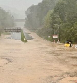
I'm sorry, can you help me with that image? The muddy river there is actually an interstate highway?
- Messages
- 3,951
No, it’s US 74 but it’s a 4 lane highway.I'm sorry, can you help me with that image? The muddy river there is actually an interstate highway?
circlesky88
Esteemed Member
- Messages
- 619
Sun actually came out at my house in Raleigh just now
superrific
Master of the ZZLverse
- Messages
- 12,127
Hmm. That is what the caption says. I confused it with I-74, probably because I've driven on that and not on the other (to my knowledge). The 4 lane highway is the more important point, though.No, it’s US 74 but it’s a 4 lane highway.
Here is a picture of the same spot from Google maps:

 www.google.com
Google Maps
Find local businesses, view maps and get driving directions in Google Maps.
fourheels
Honored Member
- Messages
- 981
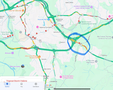
Yes, it's a sizeable interchange on the eastern edge of Asheville two exits east of the main Biltmore exit. If the camera did a 180° it would be looking northwest up the I-240 loop which starts there from US-74Hmm. That is what the caption says. I confused it with I-74, probably because I've driven on that and not on the other (to my knowledge). The 4 lane highway is the more important point, though.
- Messages
- 2,055
Upvote for Hollow.
Share:


