The Weather Thread

  • Thread starter Thread starter nycfan
  • Start date Start date
  • Replies: 319
  • Views: 6K
  • Off-Topic 
A friend just texted as they are trying to evacuate the Tampa area. Traffic is awful and gas stations are already running out of fuel. He is trying to get to a family house in Georgia. ETA 1am, he has 3/4 of a tank currently. Hoping to find gas close to the FL/GA line (insert bad country song here).
 
The dry air dropping south(which will give NC gorgeous weather this week) is going to get sucked into the hurricane as it approaches Florida and that will weaken it some.
 
The front will weaken Milton through the southern jet, but I wouldn't count on the dry air.

If you have family in the Tampa area and their elevation is 20 feet or less or they aren't rated for 150 mph winds and even if they are have them GTFO.


Hurricane Milton Discussion Number 11
NWS National Hurricane Center Miami FL AL142024
400 PM CDT Mon Oct 07 2024

Satellite images indicate that Milton is quite a powerful hurricane.
The small eye has become even more distinct than earlier today, and
radar data from Sabancuy show a small, closed eye with a very
strong eyewall presentation. On the last fix before the plane
departed a few hours ago, the Air Force Hurricane Hunter crew
reported that the pressure had fallen to 911 mb, which is 77 mb
lower than yesterday at the same time, with other data to support
150 kt. Since the satellite imagery continues to show
intensification, the initial wind speed is set to 155 kt, and a pair
of Hurricane Hunters should be in the area this evening for more
information.

The hurricane is moving eastward at about 9 kt. Milton should move
close to the northern portion of Yucatan Peninsula tonight and early
Tuesday ahead of a mid-level trough dropping into the northwestern
Gulf of Mexico. This feature should then cause Milton to move
east-northeastward to northeastward at a faster forward speed
later on Tuesday and Wednesday. Little change was made to the
previous forecast, with the latest model guidance very close to the
previous forecast cycle, and this forecast remains close to a
consensus of the latest GFS, ECMWF and regional hurricane models.
Note that this track is closer to the model fields rather than the
model trackers which appear to be too far south.

Milton could strengthen even more tonight with light shear and
very warm waters providing a conducive environment. However, radar
data indicate that Milton could be at the beginning of an eyewall
replacement cycle, with some signs of a moat and a partial outer
eyewall. The evolution will likely cause the system to gradually
weaken on Tuesday but grow larger. On Wednesday, Milton is expected
to encounter a less favorable environment with strong shear and dry
air entrainment, with further weakening forecast. Regardless, the
system is expected to be a large and powerful hurricane at landfall
in Florida, with life-threatening hazards at the coastline and well
inland. Residents in Florida should closely follow the orders from
their local emergency management officials, as Milton has the
potential to be one of the most destructive hurricanes on record
for west-central Florida.


Key Messages:

1. Damaging hurricane-force winds and a life-threatening storm surge
with destructive waves are expected across portions of the northern
coast of the Yucatan Peninsula through tonight.

2. Milton is expected to grow in size and remain an extremely
dangerous hurricane when it approaches the west coast of Florida on
Wednesday. A large area of destructive storm surge will occur along
parts of the west coast of Florida on Wednesday. This is an
extremely life-threatening situation and residents in those areas
should follow advice given by local officials and evacuate
immediately if told to do so.

3. Potentially devastating hurricane-force winds are expected along
portions of the west coast of Florida where a Hurricane Warning is
in effect. Milton is forecast to remain a hurricane as it crosses
the Florida Peninsula and life-threatening hurricane-force winds,
especially in gusts, are expected to spread inland across a portion
of the entire Florida Peninsula. Preparations to protect life and
property in the warning areas should be complete by Tuesday night
since tropical storm conditions are expected to begin within this
area early Wednesday.

4. Areas of heavy rainfall will impact portions of Florida today
well ahead of Milton, with heavy rainfall more directly related to
the system expected later on Tuesday through Wednesday night. This
rainfall will bring the risk of considerable flash, urban, and areal
flooding, along with the potential for moderate to major river
flooding.
 
A friend just texted as they are trying to evacuate the Tampa area. Traffic is awful and gas stations are already running out of fuel. He is trying to get to a family house in Georgia. ETA 1am, he has 3/4 of a tank currently. Hoping to find gas close to the FL/GA line (insert bad country song here).
"Is there gas in the car? Yes, there's gas in the car."
 
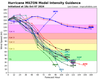
14L_intensity_latest.png

If I am reading that right, four models have it hitting land as a cat 5.
Cat 3, 4, or 5 are all catastrophic. Cat-5 would obviously be worse than a Cat-3, and again, I'm not a meteorologist, but I think WHERE it makes landfall may be more important than its windspeed. A Cat-3 north of Tampa Bay could be significantly worse than a cat-5 south of Tampa Bay because of storm surge into Tampa Bay itself and the resulting flooding.

The fact that it has gone from a tropical depression to Cat-5 in only 46 hours and may still strengthen is reason for alarm.
 
Eye Wall Replacement in progress It will drop in intensity , but likely " reintensify" .But only Baby Jesus knows if it goes all the way back to where it was a couple hours ago Later tommorow it will run into westerly shear winds-which should lower intensity some as it spreads the storm out
 
Why is Milton forecasted to weaken before making landfall?

Also, in terms of forecasting, yesterday or the day before it was forecasted to become a Cat. 3 at the top end……today, it’s a 175 mph Cat. 5.
Drier air ahead and bumping up against a cold front. Right now landfall is projected as Cat 3 (not good at all for Tampa area) with only a slight chance for Cat 2.

But that is as of now. They have been pretty accurate though.
 
14L_intensity_latest.png

If I am reading that right, four models have it hitting land as a cat 5.
Not just that.

It STAYS as strong as a Cat 4 all the way across the state. I mean you are talking Disney and Universal could be absolutely obliterated. Daytona destroyed, etc.
 
Drier air ahead and bumping up against a cold front. Right now landfall is projected as Cat 3 (not good at all for Tampa area) with only a slight chance for Cat 2.

But that is as of now. They have been pretty accurate though.
Appreciate the info.

I’d say the forecasters haven’t “been pretty accurate.”

They weren’t calling for it to become a hurricane as quickly as it did and they sure as shit weren’t forecasting a sustained 180 mph Cat. 5 storm for today.
 
Back
Top